Holdout Canyon
November 14, 2008
On our way to the the east end of Aravaipa Canyon earlier this year, we discovered the Sulphur Springs Valley, which drops over 1500 feet from Willcox north to Klondyke, Arizona, passing by an intriguing pile of rock bounded by the Santa Teresa Wilderness. This is one of the most inaccessible wild areas in all of Arizona, and has the state's highest concentration of mountain lions. Access is limited to two rough 4WD drive roads on the south and west sides. There are no maintained trails within the wilderness, and maps of the area are wildly inaccurate. Against all odds, we made our way into the canyon, thanks to information provided by Brett aka "blisterfree" on his Grand Enchantment Trail Blog. With our friends Jim and Jacki from Willcox, we set out on a grand adventure:
Fuzzy Directions by Marion
We followed FR 94 5.8 miles, passing through an unlocked gate and avoiding spur roads to the right and left. At the top of the ridge, we turned right on an unmarked road, heading toward an unnamed peak with an elevation of 6000 feet. In .4 miles, we came to a fork with Poncho Tank indicated on the left, and Reef Tank indicated 3/4 miles on the right. We turned right and descended a hellacious hill. If you have any doubts about your vehible, it might be better to park here and walk down. The road ends at a clearing near a large cattle tank, GPS f N32° 54.4467' W 110° 18.2090'. There is no obvious trailhead, but after poking around in the brush a while, we were thrilled to find a single orange ribbon, and then a small cairn. In the morning we followed these traces up a wash, and then crossed four low ridges to reach upper Holdout Canyon. There is no correlation between "Holdout Canyon Trail" as shown on our GPS/TopoUSA.
Details by Dennis
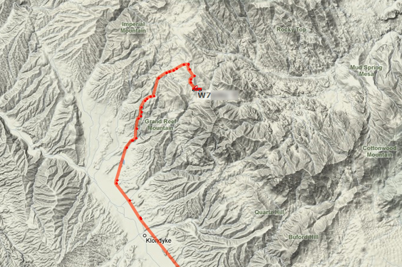
The red lines on the two maps that follow indicate the track of our vehicle to from Klondyke to the edge of the Santa Teresa Wilderness. Amateur radio stations that equip a vehicle, horse, bicycle or handheld radio with an Automatic Position Reporting System (APRS) device can be tracked in real-time on the internet. A GPS device sends latitude and longitude coordinates to a radio or controller box. The radio or controller has a very small computer chip that looks at the position data and triggers a transmitter to send a modem-like signal at (144.390MHz FM). You can hear local signals with a radio scanner set to that frequency. Repeaters located high on mountains retransmit the signal for wide coverage. Amateur radio stations receive the data, decode it and upload it in real-time to APRS servers connected to the internet. Some generous Hams (amateur radio operators) have written web applications that present this data graphically using a web browser. These topo map fragments are from a browser display made by http://aprs.fi.

The yellow trail is our hike as interpolated from a few handheld GPS readings that were manually added to the map.

